YKTN Airfield Information
NOTAMS
1. Following recent taxiway sealing works, PICs are advised there are some locations with loose stones and are advised to use low power settings along taxiways.
2. Grass surfaces to the East of the RWY 18/36 outer Gable/Cone line are unserviceable and must not be used.
3. The gravel area to the North of RWY 18/36 is unserviceable and must not be used.
4. Animal hazard exists, including, but not limited to, Kangaroos, Sheep, Goats and Birds.
Kyneton Airfield (YKTN) is owned by the Macedon Ranges Shire Council and managed by the Kyneton Aero Club. Visiting aircraft and pilots are always welcome, please check ERSA, NOTAMS and the information below.
For non-members, prior permission is required to use the airfield. This is to ensure that pilots have visited this page and understand our operational and fly-neighbourly requirements. Use for flying training by other organisations is not permitted and we limit access for very noisy aircraft. Our Landing Permission form is here.
An exception is made for police, fire, search and rescue, other emergency services and infrastructure-monitoring organisations when the need arises.
The clubhouse is locked when not in use however, toilet facilities remain accessible. YKTN is about 3 km from town, though there may be no taxi service available.
AVGAS is available 24/7 via a self-service bowser. Payment is via the iOR Aviation tag for account holders or via the free ‘FuelCharge’ App available for IOS and Android. There are no Credit Card or EFTPOS facilities available.
A visitor aircraft parking area is located on the grass to the South of the Aero Club building and to the West of the Run-up Bay and is clearly signed. The area to the North of the AVGAS bowser is reserved for Kyneton based aircraft. Parking fees may apply for extended stays. Full details of Airfield Access fees are available here
The Macedon Ranges Shire Council’s Kyneton Airfield Operations Manual is available at: https://www.mrsc.vic.gov.au/files/assets/public/v/5/see-amp-do/our-facilities/our-venues/kyneton-airfield-operations-manual.pdf
It is a requirement that all Pilots and Aircraft Owners, whether visiting or based at, the Kyneton Airfield, make themselves familiar with, and abide by, this Operations Manual.
Weather Station and Cameras
Our weather station is updated every 15 minutes however if offline, the closest alternative weather station is here.
Fly Neighbourly Noise Abatement Policy
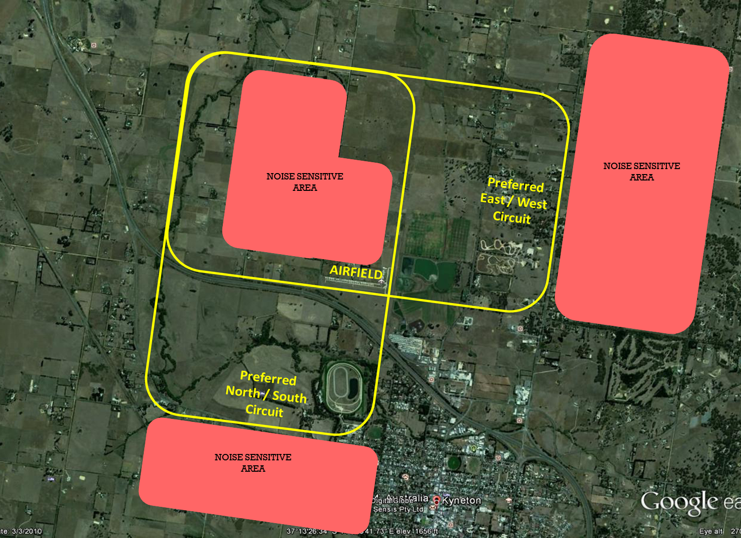
The Fly Neighbourly Policy referred to in ERSA, protects noise sensitive areas near the airfield as set out in the diagram below. Please avoid these noise sensitive areas and, subject to operational and safety requirements, comply with the preferred circuit patterns.
Please avoid using high power settings when operating below 1000′ near these noise sensitive areas